

In addition to the instructor radishes, you will find biting horse flies, burning hogweeds (the plant is burdock-like), frequent crossings and fords, rock landslides and loose rocks along the route. The elevation changes alone are worth a lot. The physical activity will be first class. Are you ready?
What to expect from a trip to the Caucasus.
In addition to the instructor radishes, you will find biting horse flies, burning hogweeds (the plant is burdock-like), frequent crossings and fords, rock landslides and loose rocks along the route. The elevation changes alone are worth a lot. The physical activity will be first class. Are you ready?
Hiking plan.
RouteRoute map
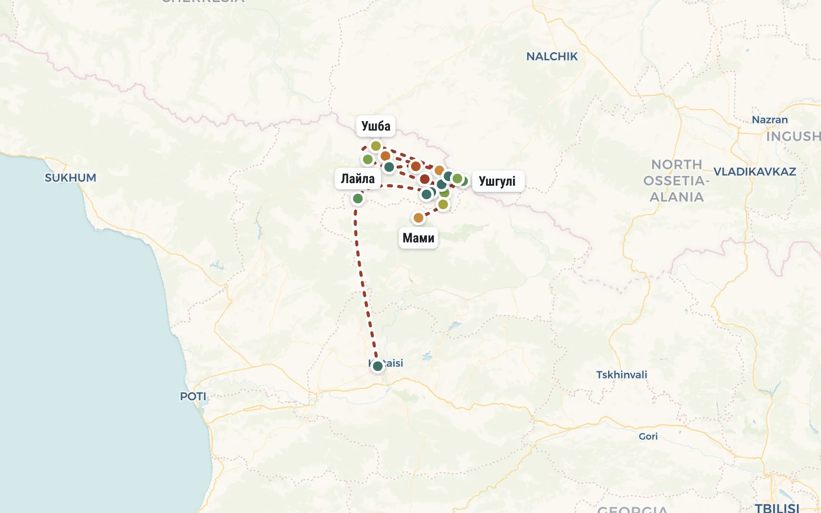 Open the map →
The GPS track is not digitised yet, the line is approximate (by key points).
Along the trailWhat you will see


Day by dayItinerary
1 Day 1. Flight to Georgia. Group gathering in Kutaisi.
Group gathering at a pre-booked hostel in Kutaisi. The time of arrival in Kutaisi does not matter - arrive either early in the morning (then you can take a walk), or late at night. UIA flies from Kyiv to Kutaisi (website flyuia.com), round trip tickets cost only $200 for a direct flight. The cheapest way to get from Moscow to Kutaisi is by the same UIA (with a transfer in Kyiv). This flight costs $240.
If it is more convenient for you, then you can fly not to Kutaisi, but to Tbilisi or Batumi. There is a bus service between all these cities and in half a day you can get to the gathering place in Kutaisi relatively inexpensively.
In the hostel you can store things you don’t need during the hike - decent clothes, beach accessories (if you’re going to the sea later), etc.
2 Day 2. Moving to Yetseri
Early rise. We are going by minibus to Svaneti. On the way we make a photo stop at the titanic dam of the Inguri hydroelectric power station.
The journey takes about 5 hours. To stretch our legs after a long journey, upon arrival in the village of Etseri, we do not immediately stop for the night, but walk up the valley for a couple of hours. Overnight in tents overlooking the Svan Range and Laila.
Distance 4 km. Elevation gain: 300 m.
3 Day 3. Baki pass, Mazeri village
Early start. Smoothly gaining speed and form. The height of the pass that needs to be taken today is 2416 meters, so it won’t be easy if you’re not used to it. Overnight in tents on a lawn near the village of Mazeri (altitude 1600m).
Distance 15 km. Total elevation gain: 946m, drop: 1556m.


4 Day 4. Radial to the Ushba glacier
We leave our things in the village, go to the radial camp lightly (take only water, a lunch snack, raincoats). But don’t let the lack of heavy backpacks fool you - the walk is far and long (6 hours uphill, 3 hours downhill).
Our goal is the 2700 m mark - the foot of the Ushba glacier, where the base camp of climbers planning to conquer this most beautiful peak of the Caucasus is located. On the way we pass several large waterfalls (their sources are on the same glacier).
In the evening we return to Mazeri.
Distance 18.6 km. Total elevation gain: 1554m.


5 Day 5. Guli Pass (2960m).
Trekking from Mazeri to Mestia via the Guli Pass (altitude 2960m).
Along the road, as expected, we cross a couple of high-altitude zones - first a forest, then mountain pastures, and finally solid rocks.
From the pass we admire a new perspective of Ushba, the Tetnuld massif and the Svaneti ridge are also visible.
We stop for the night just below the pass on the first flat platform. Overnight in the company of Georgian horses :)
Distance per day: 13 km. altitude gain: 1697m.


6 Day 6. Lakes Koruldi.
We go down even lower, cross a gorge with another turbulent river, and traverse the slope. After lunch we make a radial trek (without backpacks) to the unique mountain lakes of Koruldi. Green grass, water surface and snowy peaks behind - a great background for a new avatar :)
Having returned to our backpacks and recaptured them from the ubiquitous Georgian cows, we continue our descent to the large village of Mestia. Overnight in a guest house.
Distance: 17 km, elevation gain: 500m.


7 Day 7. Half day in Mestia.
In the first half of the day we walk around the village of Mestia, go to the house-museum of the legendary climber Khergiani, and climb one of the Svan towers. Did I forget to tell you about the towers?! Svaneti is the land of 1000 towers. In the 9th - 12th centuries, the proud Svans built a great many of these housing and defensive structures. They look extremely picturesque against the backdrop of the mountains, giving the valleys of Svaneti a special flavor.
Then we replenish food supplies and pack our backpacks. We take a chartered minibus for about half an hour to the village of Zhabeshi. Then we climb the slope slightly and as soon as we find a site with a gorgeous view, we immediately set up camp. The height is about 2500 meters - the peaks of the Main Caucasus Range, the already familiar Ushba and the distant towers of the Enguri Valley are clearly visible.
Distance: 3 km, elevation gain: 300m.


8 Day 8. Transfer to Adishi.
Soon after the start we come out onto a dirt road along the ridge and continue to gain altitude along it until about lunchtime. We eat at the observation deck and begin our descent along the grassy slope. Overnight on the river bank near the village of Adishi (2040m).
Distance 12 km, elevation gain: 1276 m.


9 Day 9. Chkhutnieri pass (2740m).
We walk along the right bank of the Adishishchali River. At the foot of the Lardaadi glacier (formed on the Tetnuld-Adishi mountain range) we cross the river and begin a steep climb to the Chkhutnieri pass (2740m).
Along the way you will have to cross many streams and small streams. At the end of the path we pass the ruins of the legendary settlement of Khalde for the Svans (a symbol of the irreconcilable struggle against the conquerors).
We spend the night in the village of Iprali (1890m).
Distance: 14.4 km, elevation gain: 939 m.


10 Day 10. Trekking from Iprali to Ushguli.
If we’re lucky, we catch some kind of transport so as not to stomp along the road, but spend more time examining the ancient architecture (churches, towers, houses) of the Ushguli community (altitude 2100m).
After lunch we climb a little higher along the Inguri River valley to shorten the long journey.
Distance 10km, elevation gain: 965m, drop: 763m.


11 Day 11. Radial to the Shkhara glacier.
The hike to the Shkhara glacier will take about 6 hours, we walk along the Inguri River. On the right side is the plateau of the Namkwani glacier, on the left is the Shkhara wall (5150 m).
At an altitude of about 2400 meters we reach the foot of the glacier.
A stream of water (the same Inguri River) quickly bursts out from under it with noise. Snow blocks and stones periodically fall off the glacier.
Don’t forget to soak your shoes, as here you will again have to cross numerous streams. If we have the strength, we will climb a little higher to the “side”; in good weather, Kazbek is visible from there.
After lunch we return to base camp, collect tents and head to Ushguli.
Distance: 12 km. Elevation gain 500m.


12 Day 12. Climbing to the Svan ridge.
From Ushguli a long climb to the Svan Ridge begins. But our backpacks are already lighter, we have trained, and the views around are simply stunning, so the walk will be easy and interesting. In fact, the Svan Range is a giant observation deck for thoughtful contemplation of the Main Caucasus Range. We stop for the night near the lakes in the saddle on the ridge crest.
13 Day 13. Descent to the village of Mami.
We finish the traverse of the Svan ridge and descend to Lower Svaneti, to the village of Mami. This village has asphalt. And if we are lucky with the weather and we go down early, then we can try to leave for Kutaisi today. Then tomorrow can be used for a holiday at sea in Batumi.
14 Day 14. Transfer to Kutaisi or the sea and Batumi.
If you didn’t get from Mami to Kutaisi yesterday, then we’ll do it today (4 hours by minibus). Well, or if we were lucky yesterday, then we go to Batumi (2 hours), swim in the sea and be sure to eat Adjarian-style khachapuri. You can’t leave Georgia without this :)
Those who have early flights tomorrow will return to Kutaisi in the evening.


15 Day 15. Flight home.
Although theoretically we should complete the trekking program and descend into the city on the 13th day, in practice we may need more time to complete the route. For example, in case of bad weather. Therefore, it is advisable to plan your flight home on the 15th day (and not on the 14th).
DetailsIncluded
- 🧭Instructor services
- 🍽Field meals on the route
- 🧭Group first aid kit (instructor's)
- 🎒Camping kitchen (burner, boilers, etc.)
Not included
- ✕Flight to Georgia - from $ 200 (this is the approximate price for round-trip tickets)
- ✕Moving around the country
- ✕Accommodation in a hostel
- ✕Medical insurance
- ✕Accommodation in guest houses on the route
- ✕Food in restaurants
- ✕Visiting paid attractions (museums), etc
- ✕For all these expenses, you should bring at least $200 per person
Trip conditions
We sleep in tents for most of the trip. And only a couple of times - in guest houses in the mountain villages of Svaneti. We cook food mainly on a burner (the instructor will have it and other kitchen equipment). We buy food for the hike partly at home (we will tell who to buy what, and then return the money), and partly in Georgia, after which it is distributed among the backpacks of the participants. Each carries approximately 4-5 kg of food.
The route is subject to changes (depending on the weather, the condition of the group and our wishes). To participate in a hike in Svaneti, the following are required: experience of hiking and the absence of medical contraindications. To travel abroad you need a passport:)


