

The Lycian Way is one of the best hiking routes in Europe, passing through the Taurus Mountains that adorn the Lycian Peninsula (Mediterranean sea). Hiking around Turkey is much more interesting than an “all-inclusive” trip to Turkey. In addition to gorgeous beaches and picturesque coves, you will see mighty mountain peaks, and along the way you will get to know real, non-tourist Turkey.
The eastern section of the Lycian Trail is more mountainous compared to Western and Central Lycia. There are a little more mountains and a little less sea. The route is built according to the classic “mountain-sea hike”. First we storm the peaks and passes, and at the end we go down to the coast to relax on the wild beaches of the Mediterranean Sea.
There is also Google map of the Lycian Way
The total length of the “original” Lycian Trail is about 500 kilometers. It would take much longer to get through them than most of us can afford. Therefore, we included only the most interesting 132 kilometers in this route. The Lycian Trail, where high mountains, deep canyons and azure bays are most harmoniously combined. In addition, there is an easier hike "Western Lycian Way" covering the coastline from Fethiye to Demre.
To participate in this hike you do not need special skills or extraordinary physical data; the experience of one or two people will be enough. multi-day hikes in the Crimea or the Carpathians. However, mountains always remain mountains - there will be no "balls". Daily 600-800 meters await you altitude gain, changeable weather and, of course, a heavy backpack on your shoulders (it’s quite possible to “fit in” with 15 kg).
Trek plan:
RouteRoute map
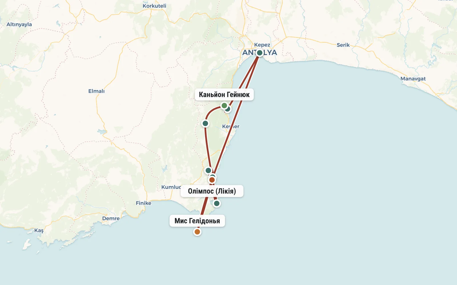 Open the map →
The GPS track is not digitised yet, the line is approximate (by key points).
Along the trailWhat you will see


Day by dayItinerary
1 Day 1. Group gathering in Antalya
All participants in the hike are from different cities and countries. They fly to Turkey on their own on different flights, at different times. To Antalya You can fly relatively inexpensively with Pegasus, Atlas Glogal, and Turkish Airlines. In most cases, these are flights with a transfer in Istanbul. If you arrive in Antalya a day earlier (to relax after the flight and see the city), then we can recommend you inexpensive hotel in the historical center of the city.
The group gathering and meeting with the instructor takes place at the Antalya bus station (Otogar in Turkish). From the airport or from the city center you can easily get there by tram AntRay.
Usually the meeting at the otogar starts at 11 am (the administrator will tell you the exact time). The instructor distributes public food (approximately 5 kg per person), checks equipment, talks about the route, and answers questions. In addition, at the bus station you can exchange currency for lira and have a snack. Closer to noon, we take a minibus and go to the resort village of Goynuk (2 hours drive), where our hike along the Lycian Way begins. However, upon arrival in Goynuk, we first go to the beach, where we will spend about an hour. Then we have lunch in a cafe and only after that we finally put on our backpacks. From the sea to our parking lot near the Harmony Canyon, 3 kilometers along the trail along the river. We put up tents and relax.


2 Day 2. Canyon of Harmony (Goynuk, 110m).
Today is a difficult day - we get up early and break camp, there is a lot to do and see. We enter the Harmony Canyon (aka Goynuk Canyon), leave our backpacks for storage in a local cafe and, lightly (with cameras, money, swimsuits and towels), set off to the most interesting part of the gorge. There you can not only admire the rocks and the purest mountain water, but also rent a wetsuit, life jacket and helmet (about $10) and swim deep into the canyon to the famous hanging stone and waterfalls. This is a real attraction - you swim a couple of meters, then walk, then climb a waterfall, jump into the bathtub and swim again. This is where a waterproof camera or other waterproof camera comes in handy.
After swimming in the canyon, we return to our backpacks, have lunch and begin one of the most difficult sections of the Lycian Way. We have to gain about 400 meters heights in order to cross the ridge to bypass the impassable section of Harmony Canyon. The climb seems to be small, but it’s very tedious and tiring (it’s hot here despite the forest and partial shade). Before starting, fill your bottles with plenty of water, because... the next source will only be for the night. At the pass we rest a little and begin the descent to the river. Today we will spend the night in the forest near the most beautiful baths (you can freshen up after a hot day).


3 Day 3. Foothills of Andizli-Tepe, upper reaches of the Harmony Canyon, Goynuk Yayla (950m), village. Gedelme (700m).
We again walk along the familiar river (upstream). The canyon here is not too deep, but the huge boulders are damn picturesque. Let's jump from stone to stone, from shore to shore, until we reach inhabited areas - almond and pomegranate orchards begin. Lycian Way goes out onto a plateau (“yayla” in Turkic).
The walk became much easier - a wide dirt road with almost no elevation gain. In the evening we descend to the village of Gedelme. Right above the village the huge Teke-Dag looms. It's beautiful... but we won't go there. We rush to restock our supplies at the local store and, if we're lucky, some recharge phones and cameras.
We camp for the night in a clearing near the ruins of a Genoese fortress. There are also two more local attractions - a huge a plane tree over 2.5 thousand years old and a small karst cave with sinter formations.


4 Day 4. Yayla-Kuzdere (900m), Chukur-Yayla (1600m).
In the first half of the day we walk along a relatively easy road that gradually rises (300 meters) to the tiny mountain village of Yayla- Kuzdere. Immediately behind it begins a steep climb through the forest. To catch our breath a little, we’ll sit down for lunch in the shade of the plane trees shepherd's hut with an excellent source.
Then the ascent continues in a calmer manner - along a dirt serpentine road through the dark “northern” forest we will slowly but surely move up until we reach a fairy tale. I'm not kidding - this is a real fairy tale called Çukur-Yayla. Huge Lebanese cedars, bizarre rocks eaten away by karst sinkholes and the mighty Olympus (Tahtali) above our heads.
We set up tents and stock up on firewood for the evening gathering. Chukur-Yayla is located at an altitude of more than 1600 meters, at night the temperature It can easily drop to 0 degrees, so it is better to prepare warm clothes in advance and dry wet things.


5 Day 5. Saddle of Olympus (1815m), peak Takhtali (2366m), village Beichik (630m).
Today is the most difficult day of the hike. We get up before dawn (like real climbers), have a quick breakfast, pack up the camp and We climb 200 meters up to the saddle of Olympus. Here we hide our backpacks in a crevice and go to the ascent, taking with us raincoats and money. It takes two hours of continuous climbing up a bare rocky slope to the top. In the spring you can easily find leftovers here snow, so it is advisable that your shoes do not look too much like beach slippers. However, wet sneakers will dry quickly under the Turkish sun, so you can just take a change of socks with you.
We start early in the morning to reach the summit before the afternoon clouds gather and envelop the mountain. From the top of the Turkish Olympus - Mount Tahtali (2365 m) you can see the entire coast from Antalya to Finike. And on the opposite side you can see the mighty Bey-Dag mountain range (3070 m) and in general everything is visible... if you catch it before the clouds.
Having admired the beauty of Turkey, we will begin our descent. If you have problems with your knees, then this is no less, and maybe even more of a test, than lifting (I recommend get trekking poles and knee pads). We go down to the backpacks, where we have lunch and dry our shoes. Then the route goes through another enchanted forest with mighty cedars, sudden fogs and dizzying views. We arrive in the village of Beychik and take a minibus. Another hour's drive and we are at the sea, in the village of Chiraly. We set up camp in a campsite 50 meters from the beach and 10 meters from the store. There is a shower, toilet, socket, kitchen. During our stay in Cirali we have dinner at a restaurant, have breakfast at the campsite, and sleep in tents.


6 Day 6. Radial boat to Cape Gelidonia or to Karaburun Bay.
Experience has shown that due to the heat, walking along the sea with a backpack is not very fun. Therefore, we leave our things at the campsite in Cirali and from the very In the morning we go to a large radial (for the whole day). We have 2 route options to choose from:
In the evening, at dusk, we will catch a minibus again and go to the main local attraction - the lights of the Chimera. According to Greek myths, the Chimera is a fire-breathing monster assembled from spare parts (lion, goat, snake). The ancient hero Bellerophon on the winged Pegasus defeated the Chimera and her body fell into a gorge near the present village of Chiraly. The legendary monster is buried under a layer of rock, and only tongues of fire have been breaking out to the surface for many thousands of years. And that’s all tourists need - many take food with them and fry it in the flames of the legend.


7 Day 7. Ruins of Olympos, transfer to Antalya.
We dedicate the morning entirely to the sea. You can just swim, or you can rent sea kayaks (1 and 2-seater boats) and sail around the most picturesque Musa Dag ridge in search of half-flooded caves and rocky corridors. Only after splashing enough we return to Chyraly... only to immediately move forward in a small radial (1.5-2 hours) to the ruins of Olympos. Olympos - a huge complex ancient ruins, which will delight us with Lycian sarcophagi, a Greek theater, Roman gates, and a Genoese fortress. B all this is in a real Turkish jungle. Water flows from everywhere, streams flow into the river, the river into the sea, and the sea... the sea still calls and beckons. The main thing is not to forget that at about 15:00 a minibus is waiting for us to take us to Antalya. Hiking the Lycian Way is complete!
Around 17:00 we arrive in Antalya, at an already familiar hotel. Most of the group (along with the instructor) will go to the bus station this evening for an overnight take a bus to Goreme. They will continue their adventures in the form of a 3-day trip through Cappadocia (a land of unreal landscapes and underground labyrinths). Join us!
If you can’t go on a tour of Cappadocia, then you can stay in Antalya. If you want to fly home today, look for the latest flights. Don’t forget about the time it takes to get to the airport (40 minutes) and registration (2 hours).


DetailsIncluded
- 🧭Instructor services
- 🍽Three meals a day on the route
- 🎒Public equipment: boilers
- 🎒Burners
- •Remnabir
- 🎒Group first aid kit
- 🎫Consultations on preparation and assistance in buying tickets
Not included
- ✕Not included in the price of the tour
Trip conditions
To travel around Turkey you need a passport! But a visa is not required for citizens of Ukraine, Russia and Belarus. Upon arrival, you are simply given a border crossing stamp in your passport. Of course it's free.
All overnight stays are planned in tents, although in some cases, if desired, you can stay in shelters or guesthouses. The instructor is in charge of organizing meals and purchasing food for the hike. Some of the food will be purchased before the hike, and some will be purchased in village stores along the route. In Turkey it is impossible to get some camp delicacies like normal sausage, stewed meat and condensed milk, so we will ask you to buy and bring some products to Turkey. We will return the money for them during further mutual settlements.
The instructor reserves the right to make changes to the route depending on weather, group condition and other factors.
ReviewsTraveller reviews
You always have a choice. My choice has already been made and I recommend it to you! OutdoorUkraine and instructor Kirill Yasko opened for me the world of organized hikes, when you are not an observer, but an active participant in what is happening.
Feeling of freedom! What I love about hiking is the sincerity of emotions, smiles, and sensations! I was once again convinced that the “wrong” people don’t go hiking. An excellent international company, the kindest people with a wealth of interesting stories behind them!!!
In general, every new day of the hike necessarily brought new impressions. It was never boring, quite the opposite. And the final part of the hike is just a blast. When the peak has already been conquered, the plan is completed... The mountains are already behind you, and ahead there is only sea, sun and relaxation.
I would like to note that the route was prepared masterfully - difficult sections harmoniously alternated with simple ones, landscapes replaced each other like pieces of glass in a kaleidoscope, and “points of interest” evenly scattered along the entire route did not let you get bored.
Many thanks to our friendly group! Guys, thanks to you, our hike (and these videos) became ten times more interesting and fun. I hope we meet again. Our planet is big, the mountains are beautiful, our backpacks are big - let's go hiking!
In addition to the joy of surprise, we also learned the joy of overcoming. As befits tourists, we overcame kilometers, altitude, fear, heat and cold. All this struggle resulted in healthy sleep and excellent appetite.
What I took away most valuable from this adventure for myself is that I know how to spend a vacation and even relax! Yes, yes! This is a vacation that inspires and gives energy for a long time... until the next trip.
If we compare tours from the “hiking by the warm sea” category, namely hiking in Turkey, Crimea and Cyprus, then it seems to me that Türkiye is definitely the most interesting of these three. Compared to Crimea, the mountains here are more similar to mountains - they are higher and forested. They leave a more vivid impression than the Crimean mountains.
The second time we celebrated the New Year on the street and the first time in the mountains. What can I say? Better than on Red Square last year.
On a hike, I consider the most important thing to be the route (its interestingness, beauty, difficulty), the company you are going with and the weather. We were 100% lucky on all three counts. Therefore, I am absolutely happy.


